Automated Geotechnical Drill Core Verification
CoreVerify processes drill core photographs using advanced AI to verify critical geotechnical parameters.
Join our mailing list to receive updates and to gain early access.
What we do
Our Solution
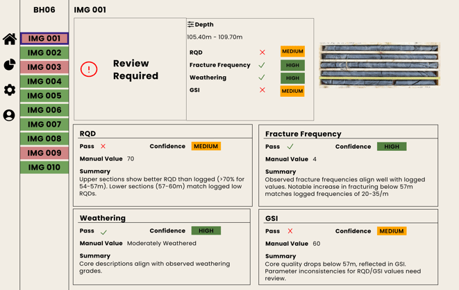
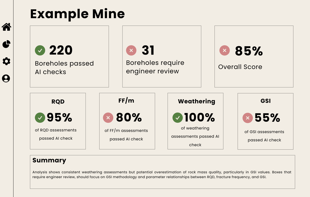
CoreVerify uses AI to automatically review all your drill core photographs, verifying critical geotechnical parameters and flagging potential issues for expert review.
The Challenge
Traditional geotechnical core logging quality control relies on manual spot checks, limiting verification to small sample sizes.
Our system automatically reviews core photographs against logged parameters, helping engineering teams identify data quality issues and maintain consistency across large datasets
How it works

Geotechnical Parameters We Verify
Rock Quality Designation (RQD)
Fracture Frequency (FF/m)
ISRM Weathering Classification
Geological Strength Index (GSI)
Overall Rock Mass Condition
Coming Soon: Joint Count, Rock Mass Classifications, Q-system and more
Cross-Parameter Validation
Our AI automatically checks for logical relationships between different parameters, highlighting potential inconsistencies in the geotechnical data. For instance, if an interval shows a high Geological Strength Index (GSI) but a low Rock Quality Designation (RQD) - a combination that experienced engineers know is unusual - the system will flag this for review. This helps maintain data quality and reliability across your entire geotechnical dataset.
Industry Applications
CoreVerify supports geotechnical analysis at every project stage, serving diverse users from consultants, site engineers to large-scale field programmes
For Site Engineering Teams
Extract maximum value from historical geotechnical databases and basic logs while managing uncertainty. Verify existing data efficiently instead of costly re-drilling.
For Large-Scale Field Progammes
Maintain consistent quality control across multiple drilling rigs with near real-time quality checks on logged data.
For Geotechnical Consultants
Review and validate client-logged geotechnical data comprehensively. Build confidence in your assessments by analysing entire datasets rather than relying on spot checks.
Smart Verification, Simple Terms
Straightforward Pricing
Our pay-as-you-go pricing model means you only pay for the photos you need processed. No contracts, no ongoing commitments - just straightforward pricing based on your needs.
Expert-Level Review
CoreVerify doesn't generate measurements - it works like an experienced engineer reviewing core photos against logged data. The system identifies potential errors and inconsistencies in recorded values, allowing you to focus your expertise where it's needed most.
CoreVerify
Automated verification for geotechnical core logging.
© 2025. All rights reserved.